Google Earth
From Wikipedia the free encyclopedia, by MultiMedia
Google Earth, is a free virtual globe formerly known as Keyhole.
It was developed by Keyhole, Inc., which was bought by Google in 2004.
Keyhole was renamed Google Earth in 2005 and is currently only
officially available for use on personal computers running Microsoft
Windows. A Linux version has been announced for the end of 2005. Google
Earth overlays satellite imagery, aerial photography and GIS information
over a 3D model of the Earth. In the USA the software has recently been
used by CNN for graphics on the large screens in The Situation Room .
Overview
Google Earth is a 3D graphics application enabling the
viewing of aerial photography and satellite images to show views of the
Earth from above in great detail. Google has taken the features of Google
Maps and merged it with the capabilities of
Keyhole, an application built by a company acquired by Google in 2004.
Google Earth enables the user to not only view these images, but also to
view many layers of data provided by Google and by the Internet community at
large. Such things as parks, rivers, roads, borders of countries, locations
of national monuments and many thousands of other places.
Google Earth allows users to search for addresses, enter coordinates, or
simply use the mouse to browse to a location. Many large cities are
available in high enough resolution to see individual buildings, houses, and
even cars. The degree of resolution available is based somewhat on the
points of interest, but most places are available at at least 15 meters of
resolution.
Google Earth also has 3D terrain data courtesy of data collected by NASA's
space shuttle and available in the public domain. This means one can view
the Grand Canyon or Mount Everest in 3D. In addition, Google has provided a
layer allowing one to see 3D buildings for some of the major cities in the
US.
Many people using the applications are adding their own data and making them
available through various sources such as the BBS or blogs mentioned in the
link section below.
Google Earth is a beta product available in a free version, and in licensed
versions for commercial use. It is currently only officially available on
Microsoft Windows 2000/XP. A Linux version should be released by end of 2005
but this looks increasingly unlikely. However, a leaked version of working
non-public beta of Google Earth for Mac OS X started to appear on the
internet on December 08, 2005.
When started up, Google Earth's view is centered on Lawrence, Kansas. The
director of engineering for Google Earth is Brian McClendon, whose online
biography says he is a 1986 graduate of Kansas University.
See also KML (Keyhole Markup Language).
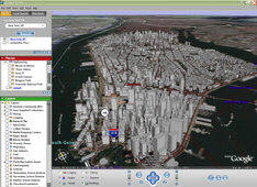
3D Buildings
A feature implemented by Google after its acquisition of
Keyhole is a 3D dataset for (as of December 2005) 39 cities. This data is
provided by Sanborn Citysets. This feature is limited to displaying grey
overlaying "blocky" buildings.
The cities currently included are: New York (Manhattan below Central Park
and West Brooklyn), Chicago (Uptown, Downtown, and residential areas north
and south of those areas along the lake), Los Angeles (Downtown, areas along
the Miracle Mile [Wilshire Blvd]), Honolulu (Downtown and along the beach),
San Francisco (the northeastern quadrant), Philadelphia (Downtown and
residential areas to the south and west), Houston (Downtown), Washington,
Boston, Dallas, Minneapolis, Miami, Atlanta, Denver, Seattle, Detroit,
Arlington, Baltimore, Saint Louis, Pittsburgh, Cleveland, San Diego, Long
Beach, Sacramento, Beverly Hills, Tampa, Fort Lauderdale, New Orleans,
Kansas City, Buffalo, Portland, Las Vegas, Jersey City, Newark, Saint Paul,
Memphis, Santa Monica.
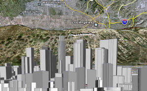
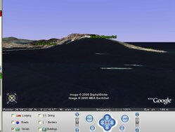
An example of Google Earth's capabilities
Specifications
- Baseline resolutions
- U.S.: 15 m
- Global: Generally 15 m (some areas such as certain oceanic
islands are in extremely low resolution, e.g. )
- Typical high resolutions
- U.S.: 1 m, 0.6 m, 0.3 m, 0.15 m (extremely rare; e.g. Cambridge,
Ma.)
- Global:
- Altitude resolution:
- Surface:
- Seabed: Not applicable (the seabed is "printed" on the spherical
surface).
- Age: Usually less than 3 years old.
Google Earth is unlikely to operate on older hardware configurations. The
most recent downloads available document these minimum configurations:
- Windows 2000, or XP
- Pentium 3, 500 MHz
- 128M RAM
- 400MB disk space
- Network speed: 128Kbits/sec
- 3D-capable video card with 16Mbytes of VRAM
- 1024x768, "16-bit High Color" screen
The most likely mode of failure is insufficient video RAM: the software
is designed to declare failure if 16 MB of video RAM is not available. The
next most likely mode of failure is Internet access speed. Except for the
very patient, broadband internet (Cable, DSL, T1, etc.) is required. Again,
resolution is not uniform, some towns such as St Petersburg are only
partially available in high-resolution
Compare the resolution of these older B&W data:
versus what is currently available with Google Earth in color
In this case, the TerraServer-USA data can identify individual trees but
its data is structured in cumbersome tiles. As with much GIS data, the
utility of the data is application-dependent for the purpose of determining
if resolution is sufficient. Also note that from a usability point of view,
TerraServer loses its center point when one zooms in and out where Google
Earth browsing is smooth; a clear benefit, but at the price of the somewhat
demanding requirements imposed upon the video card.
Mac OS X Version
Screenshots of a beta version of Google Earth for Mac were leaked onto
the internet on December 8th, 2005, a few hours later a download link was
provided on []. The leaked program claims to have been built at 10:39:53
on December 1st (timezone remains unknown); if this date is correct, then it
took a week from its build date before the program was released to the
Internet. How it was leaked remains uncertain, but Google has not released
any statement regarding the leak.
The file was a 11 megabyte zip file containing a .dmg disk image containing
the application folder (Google Earth.app)
The program itself is somewhat crippled with reduced functionality. However,
the browsing aspect is equal if not better than the windows version. The
program appears to be somewhat unstable, several users have reported it
crashing and having to forcefully quit the application. It requires the
latest version of OS X (10.4) to run due to special graphics features in
this operating system. The leaked build was version 3.1.0371.0 and it is
possible that there are other leaked builds available.
Since this is an early beta version there are some notable differences in
functionality when compared to the Windows version.
- None of the help menus work, not even the license. The absence of a
license included with the software is a sure sign that this software was
intended for Google's internal use only. Software such as this should by
right be supplied with a license.
- The full screen feature does not work at all, attempting to use this
will blank out the map until the program is restarted.
- The menu items are inconsistent and will sometimes be grayed out for
no particular reason.
- No printing support
- The add path/polygon features prompt the user to subscribe to Google
Earth Plus, however no such thing is available.
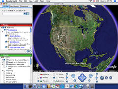
Google Earth (Mac OS X)
Accuracy
Most land areas are covered in satellite imagery with a resolution of
about 15 m per pixel, and some population centers are also covered in
airplane imagery of several pixels per meter. Oceans are covered in much
lower resolution. Due to the limited spatial resolution of the altitude map,
altitudes are often inaccurate, especially the altitude of small features,
like mountain tops; e.g. Mount Everest's height is short by 253 m, and the
sea near Gibraltar is shown with an altitude of 252 m. Unlike the satellite
images, the plane images have a perspective from close to the surface,
leading to distortions when used in a mosaic. Tall buildings sometimes
appear to be leaning towards each other (conspicuous in e.g. Chicago at
South Clark Street, in the middle of downtown). The Fatih Sultan Mehmet
Bridge on the Bosporus may be another example of this effect. The images are
not all taken at the same time, but are generally current to within 3 years.
Place name and road informatin detail vary greatly from place to place, and
are most accurate in the USA and Europe, though misplaced name tags have
been found here too, e.g. the name tags for Newcastle upon Tyne and
Gateshead are both about 2 km north of their correct positions.
The west side of Gibraltar, tilted view showing the sea rising up
Gibraltar Rock - claimed height of the sea just off the beach at Elliots
Memorial, 252 m.
Controversy
US bias
The software has been criticized for being too US-focused. Notably, the
default setting is to imperial units, despite metric units being the
international standard used by 190 out of 191 nations and 95% of the World's
population, leading to accusations of cultural imperialism. The 3D buildings
feature is also limited to major US cities only. The
search engine is also criticized for its US
focus; for example, entering in searches for "Birmingham" and for "St.
Petersburg" bring up US cities, as opposed to the original larger cities of
those names in the UK and Russia respectively. Similarly, places outside of
the US cannot be found with the search function unless the country name is
added and written out in full, while with US places, there are many easier
paths to find data. However, critics say that the majority of the Internet
is US-focused, and therefore Google is not biased but it is the web. In
addition, the majority of both Google and Google Earth users are American.
Naming disputes
Google Earth and Google Maps label most
geographical names of bays along the southeastern coast of the Korean
Peninsula with Japanese names. This provoked some angry comments among South
Korean users. Some examples are:
near Busan: Nakutogu Po (JP), Kanrai ho (JP) near Masan: Masan Ko (JP),
Kisan-ko (JP), Unchen Wan (JP) near Goseong: Kojo-wan (JP), Toto wan (JP),
Nan Wan (JP), Toei kawan (JP)
- But some more important examples are the fact that Google Earth does
not recognize the post-1967 Isreali borders, and shows Gaza and the West
Bank as "Palestine". As written by Nathan Weinberg in webpronews.com,
"What is odd is that when you zoom in on the Middle East, the West Bank
and the Gaza Strip, two areas that...are of enormous dispute within
Israel, register with Google Maps before
Israel itself. You have to go two more zoom levels to see that Israel is
indeed the name of the country, and it is printed in a much smaller font
that seems to indicate it is Israel that is a territory within others,
and not the other way around...This is despite the fact that both areas
are smaller than the rest of Israel, and despite the fact that both
areas, despite what future you believe they ought to have, are a part of
Israel."
- It also keeps the old USSR border of the era, without considering
the other former-communist countries that have formed from it.
The software was criticized by Taiwan because the island was called a
province of Mainland China. However, Taiwan is no longer listed as a
province of China on Google Earth nor Google Maps,
angering the People's Republic of China .
Google Earth also confuses towns in Poland and Germany - Jelenia Gora in
Poland is incorrectly referred to as Hirschberg, whereas Görlitz on the west
side of the border is called Zgorzelec, the name of its Polish neighbour
The software has been criticised by a number of groups, including
national officials, as being an invasion of privacy and even posing a threat
to national security. The typical argument is that the software provides
information about military or other critical installations that could be
used by terrorists. The following is a selection of such concerns:
- The Indian president APJ Abdul Kalam has expressed concern over the
availibility of high-resolution pictures of sensitive locations in India
.
- The South Korean government has expressed concern that the software
offers images of the presidential palace and various military
installations that could possibly by used by their hostile neighbour
North Korea .
- Operators of the Lucas Heights nuclear reactor in Sydney, Australia
asked Google to censor high resolution pictures of the facility .
However, they later withdrew the request .
Google Earth Community
An online forum dedicated to produce placemarks of interesting or
educational perspectives. It may be found on the Google Earth webpage or
under the Help section on the program itself. After downloading a placemark,
it will automatically run Google Earth (if not opened), and fly to the area
specified by the person who placed it. Once there, you can add it to your
"My Places" by right clicking on the icon and selecting "Save to My Places".
Additionally, anyone can post a placemark for anyone to download.
Google Earth Plus
Google Earth Plus is an individual-oriented paid upgrade to Google Earth
and adds the following features:
- GPS integration – read tracks and waypoints from a GPS device. 3rd
party applications have been created which provide this functionality
using the basic version of Google Earth by generating
KML files based on user specified waypoints . However, these
tools only
work with specific GPS devices whereas Google Earth Plus provides
support for the Magellan and Garmin product lines, who together hold a
large share of the GPS market.
- Higher resolution printing.
- Customer support via email.
- Annotation – adds draw/sketch tools for richer annotations (can be
shared as KML).
- Data importer – read address points from CSV files.
Google Earth Pro
Google Earth Pro is a business-oriented paid upgrade to Google Earth that
has even more features than the "Plus" version. The Pro version is capable
of running additional add-on software .
See also
List of Google services
and tools
- EarthSat
- Google Maps
- NASA World Wind
- TerraServer-USA
- Virtual Earth
- Google Moon
- Earth3D –
- Frappr –
External links
Google Guide made by MultiMedia | Free content and software
This guide is licensed under the GNU
Free Documentation License. It uses material from the Wikipedia.
|